PureTech Systems: PUREACTIV®
Visit www.puretechsystems.com for further information
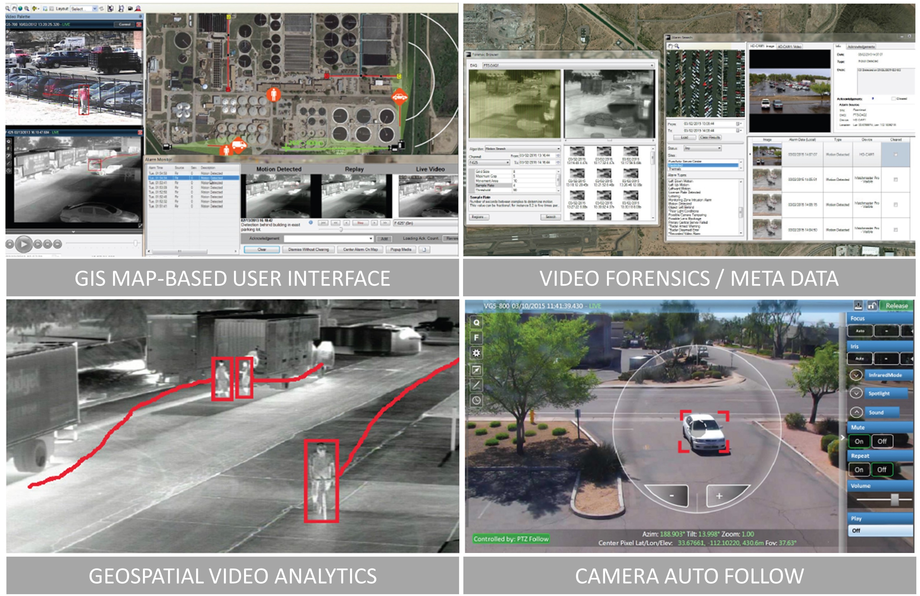
GEOSPATIAL VIDEO MANAGEMENT SYSTEM
PureActiv® is a Geospatial Video Management System (VMS) that incorporates a GIS map-based User Interface (UI) that provides ease of operation and advanced wide-area situational awareness. PureActiv® is designed to help protect borders, critical facilities, and infrastructures in many sectors. PureActiv® excels at providing security professionals with a comprehensive birds-eye view of their security situation.
GIS MAP-BASED VIDEO MANAGEMENT
PureActiv® uses GIS map technology to display camera locations and their field-of-views, other detection devices, alarm events, and target tracks. In addition to live and recorded video the user interface includes map tools such as the ability to add and share place-markers, point-and-click on the map to steer cameras to geolocations, range-to-target indicator, and a distance measuring tool.
GEOSPATIAL VIDEO ANALYTICS
The proven geospatial video analytics from PureTech Systems® outperforms other analytics in detection range, probability of detection (PD) and nuisance alarm rate (NAR). Its multistage processing pipeline includes image stabilization, shadow removal, multimodal background learning, segmentation, object recognition, and tracking. All combined these contribute to superior performance. In addition, the patented PTZ auto-follow analytic from PureTech Systems® enables PTZ cameras to automatically follow detected targets.
ALARMING AND ALARM SEARCH
For each real-time alarm, PureActiv® displays a still image, looping video, live camera view, and geolocation, regardless of the sensor type that generated the alarm. PureActiv® incorporates alarm querying based on a number of user specified metadata criteria.
ADVANCED AUTOMATED CAMERA CONTROL
When alarm events occur, cameras are automatically commanded to point at the precise geolocation of the event and zoomed appropriately. And users can simply click on the desired location on the GIS map to steer one or more cameras or acoustic deterrent devices (LRAD) to the selected location.
FEATURES
• Geospatial User Interface Provides Comprehensive Birds-Eye View
• Commercial-Off-The-Shelf (COTS) Hardware
• Continuous and Alarm Video Recording
• Live Video and Event Alarming with Geolocations
• Multiple Workstations each with Multiple Monitors
• Automated PTZ Camera Steering to Alarm Locations
• Proven Geospatial Video Analytics
• Automated PTZ Lock-on-Target Tracking
• Alarm Search and Forensic Tools
• Video and Metadata Export Tools
• Supports HD cameras
• Integrates with RADAR, Fence Sensors, GPS, AIS, Access Control, LRAD
• Language Support: English, Spanish, French
VIDEO ANALYTICS
• Recognition / Classification (person, car, truck, small boat, large boat, etc.)
• Automated PTZ Lock-on-Target Tracking
• Slew to Cued Location / Search Scan
• Geo-zone Entry / Exit
• Wrong Direction
• Speed Threshold
• Counting / Crowding / Loitering / Dwell Time
• Stopped / Dropped / Removed Objects
• Camera Tampering
INTEGRATIONS
Camera Brands: ACTi, American Dynamics, Axis, Bosch, FLIR, General Dynamics, Hitachi, L3, Moog, Panasonic, Pelco, PVP, Sony, Vicon, Vumii
Access Control Systems: JCI P2000, AMAG, Lenel, TAC, Software House, others via SNMP
Fence Sensors: Southwest Microwave Intrepid, Senstar
RADAR: FLIR, SSR, L3
Acoustic Loud Hailers: LRAD Corp.
GPS: Remote Tracking Systems
AIS: Comar Systems
Contact info:
ERIC OLSON Vice President Marketing
+ 1.480.522.6331
This email address is being protected from spambots. You need JavaScript enabled to view it.
-
Ocean Aero: Submaran UUSVNext >


")